


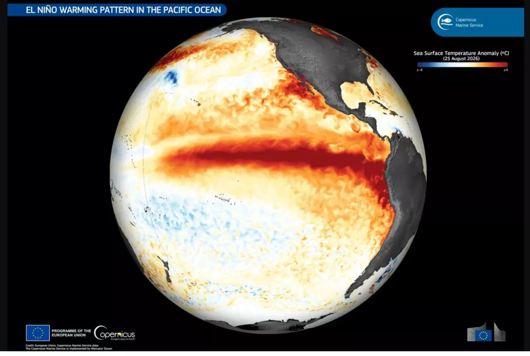
Meteorologists and climate scientists have raised the alarm about the current El Niño, which began in June, and is likely to be the largest in at least 1,000 years. It will add extra heat into an atmosphere in which temperatures are already rising rapidly due to human-caused global heating, and supercharge extreme weather events.
So what do we need to know about El Niño?
El Niño is part of a wider climate pattern called the El Niño-Southern Oscillation (ENSO) cycle. It has a cool phase, known as La Niña, as well as a “neutral” phase. El Niño and La Niña events typically last between nine and 12 months, but can go on longer.
In the Pacific, trade winds blow from east to west across the tropics, pushing warm surface water from South America towards Asia and pulling up cold water from the deeper ocean off the South American coast.
During an El Niño event, the Pacific trade winds weaken, or even reverse locally, allowing the warm surface water to spread back towards South America, suppressing ocean upwelling. This typically brings very wet conditions to the west coast of South America and leaves south-east Asia unusually dry.
The hotter waters in the western and central Pacific Ocean release heat into the atmosphere, raising global temperatures. El Niño is linked to more frequent, more intense heatwaves on every inhabited continent. Coming on top of existing global warming, this means 2027 is almost certain to be the warmest year on record.
It has been predicted that between September 2026 and February 2027 more than 450,000 people are projected to die from the extra heat from the super El Niño, not including other effects such as drought or floods. In addition, higher levels of heat deaths are expected to continue until June or July 2027.
Warmer air holds more moisture, and more energy. Some areas get much more rain - for example, the western coast of South America experiences heavier rainfall in an El Niño year as the waters heat up. In other regions El Niño brings drought, for example in Indonesia with cooler waters in the eastern Pacific.
El Niño also interacts with other global atmospheric systems, including the Indian Ocean Dipole and the jet stream. Some impacts are almost certain; others depend on how El Niño interacts with other weather patterns. As well as the information below, you can see more information here about how predictions are made, and other possible impacts.
El Niño's influence on Europe is weaker and less consistent than its effects on the tropics. The main effect for the UK and Europe during strong El Niño winters is a southward-shifted and strengthened North Atlantic jet stream that steers more frequent and intense winter storms toward the British Isles and western Europe. Having seen abnormal heat and drought throughout summer and early autumn of 2026, 2027 is likely to be another summer of heatwaves.
The big story about what is happening to our global climate isn't El Niño, it's the long-term heating caused by fossil fuels (you can see that here). This trend means that even 'cool' La Niña phases are now hotter on average than the warm ones of previous decades. But the shift in average temperatures brought by El Niño loads the dice even further, towards extreme heatwaves, extreme flooding and extreme drought and wildfires.
Rainfall in coastal Peru and Ecuador is very closely linked to El Niño flooding. Normally arid coastal regions can receive 10-30 times their average rainfall.
Further north, El Niño winters in California are characterized by atmospheric rivers — narrow corridors of concentrated moisture that can deliver as much water as the Mississippi River mouth in a single storm. Floods are also more likely in the southeastern US, Gulf Coast, Cuba & Bahamas, and in southeastern South America: Southern Brazil, Paraguay, and Uruguay
Mediated by the Indian Ocean Dipole, El Niño can also bring devastating floods to the Horn of Africa. The 1997-98 El Niño brought flooding that killed 3,500 people in Somalia, destroyed 70% of Kenya's road infrastructure, and triggered a Rift Valley fever outbreak as floodwaters expanded mosquito habitat. The 2023-24 El Niño coincided with floods in Kenya and Somalia that displaced over 1 million people.
Hot and dry conditions in Indonesia have already caused record wildfires and fatal levels of air pollution
Another region at high risk of drought and fires during El Niño is the Amazon rainforest, already suffering deforestation and deliberate fires and potentially facing an ecosystem tipping point.
Drought in Central America has wiped out crops and killed livestock for millions of smallholder farms in the 'Central American Dry Corridor, especially Honduras, Guatemala and El Salvador, causing food shortages in areas already bearing the brunt of the climate crisis, poverty and conflict.
Southern Africa is at high risk of drought and crop failures during El Niño, in a region where millions already don't have reliable access to enough affordable and nutritious food (see below)
Australia has experienced a hot and dry early spring. Drought increases fire risk, which is historically worst in the years following an El Niño (more from Australia's Climate Council here)
El Niño reduced India's monsoon rainfall in 2026, and lower than average rainfall is expected from October-December, with concerns for harvests.
El Niño increases the number of storms in the warmer eastern Pacific. In the western Pacific, El Niño does not significantly change the total number of typhoons, but it tends to changes their path, with storms starting further east and closer to the equator. This means typhoons have more time over open water before reaching land, allowing them to become more intense on average. They are more likely to make landfall in Japan, Korea, and Taiwan and miss the Philippines.
El Niño actually decreases the number of Atlantic storms as they are pulled apart by wind shear (when wind direction or speed changes further up in the atmosphere).
We often think of heatwaves only in terms of how they affect us on land, but the oceans store vast amounts of heat and local marine heatwaves can be devastating to marine ecosystems. With global temperatures rising because of fossil fuel burning, El Niño events drive repeated mass coral bleaching events which are devastating coral reefs. In response to marine heatwaves, corals expel their symbiotic algae, turning white and losing their primary food source. While reef recovery is possible, it may take 10-15 years, a recovery space which simply does not exist in our altered climate.
El Niño also affects other marine ecosystems and the seabirds and mammals which depend on them. Hotter seas are of course also a direct driver of extreme weather on land.
Scientists measure the strength of El Niño events by tracking sea surface temperatures in a section of the central Pacific. The threshold for declaring an El Niño is 0.5C in the Pacific (above the 30 year rolling average). Above 2C is informally designated a 'super' El Niño. This time, months before its peak, the temperature anomaly has already reached over 3C, breaking the all-time record for daily strength. It is predicted to peak around 4C in November and December. You can track forecasts here.
Although the science is not yet settled, evidence is growing that human-caused global warming is itself making the climatic swings of El Niño events more extreme.
El Niño can have a direct impact on regional food security. Southern Africa is one of the world's vulnerable regions to El Niño impacts. During the 2015-16 El Niño, drought caused a food crisis. Maize production in the region fell 30%, with Zimbabwe losing over half its crop. The 2023-24 event triggered national disaster declarations in Zambia, Zimbabwe, and Malawi by early 2024.
In Australia, low rainfall has affected the wheat harvest. There are consistent impacts on particular crops such as El Niño reducing cocoa and coffee harvests.
There are also indirect effects, for example when India has pre-emptively banned rice exports, this has caused a price spike in the past.
In addition, where El Niño was first historically observed on the Peruvian coast, this is where the anchoveta fishery collapses during El Niño years, from 6-10 million tonnes to under 1 million tonnes during strong El Niño events. Anchoveta are processed into fishmeal for the world's aquaculture and livestock industries. Global fishmeal prices spike, raising costs for salmon farms, shrimp operations, and poultry producers worldwide.
This El Niño is causing particular alarm for food security, because it comes on top of reduced global fertiliser availability due to the Strait of Hormuz being blocked. A third factor is the impact of continued drought on US agriculture, the latter not related to El Niño, although it is related to climate change.
The World Food Programme predicted in August that in 45 countries already considered food insecure, the total number of families unable to meet their daily food needs would rise from approximately 225 million to 274 million people by the end of 2027.
Carbon Brief: Explainer: How the ‘super El Niño’ will reshape the world’s weather 18 August 2026
Carbon Brief: Analysis: ‘Super El Niño’ breaks ‘remarkable’ all-time record 21 September 2026
Zeke Hausfather: The impacts of this year’s record-shattering El Niño 28 September 2026
4Hunger.org: Scorched Harvest: The Strongest El Niño Ever Forecast, the Crops in Its Path, and the Hunger It Will Leave Behind 18 July 2026